High Sierra
Backpacking
Trail Guide
Forums
Sierra
Weather
Gear
Lake Tahoe Basin Management Unit for long distance backpackers
Languages
Trail Skills
Mountain
Safety
Safety
Incidents
Food
Planning
40 Days to Whitney Introduction Tahoe-Yosemite
Trail Arts
More
Information
News
and
Science
Social
| permitting authorities index | next: El Dorado NF | list of National Forests | trail heads | subdivisions | other trips | links/maps | contacts |
Catching the Pacific Crest Trail South, or beginnning the Tahoe-Yosemite Trailfrom the Lake Tahoe Basin Administrative Unit |
|||||
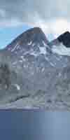
The Lake Tahoe to Yosemite Trail begins at the Meeks Bay trail head and takes you 29 miles down the length of Desolation Wilderness within the Lake Tahoe Basin Administrative Unit. (LTBAU) 11.5 miles South of Meeks Bay the Lake Tahoe to Yosemite Trail joins the Pacific Crest Trail and the Tahoe Rim Trail just North of Middle Velma Lake in Desolation Wilderness. From Middle Velma Lake Southbound backpackers follow this combined trail 17.5 miles to Echo Lake, where the Desolation Wilderness ends, though you continue South within the Lake Tahoe Basin Administrative Unit. Two miles south of Echo Lake the Southbound backpacker enters the Meiss Country Roadless Area when passing through Echo Summit. The PCT, Tahoe to Yosemite, and Tahoe Rim trails continue together through Echo Summit to Meiss Cabin, where the Tahoe Rim Trail turns Northeast towards Round Lake to follow the Eastern Shore of Lake Tahoe. The Tahoe Yosemite and Pacific Crest Trails continue South to the Carson Gap, where they part company overlooking the Carson Pass. On both the Pacific Crest and Tahoe to Yosemite routes the Southbound Backpacker is exiting the Lake Tahoe Basin Administrative Unit just South of the Carson Gap. The PCT hiker will be entering the Toiyabe National Forest Administered section of the Mokelumne Wilderness, while the Tahoe to Yosemite backpacker will enter the El Dorado NF administered section of the Mokelumne Wilderness. But first, both Southbound routes pass through the tiny Carson Pass Management Area on their respective routes. If your backpacking trip South on the Pacific Crest Trail Route South from the Carson Pass Management Area should consult the Toyiabe National Forest. The backpacker starting the Tahoe to Yosemite Trail South from the Carson Pass Management Ares should consult the El Dorado National Forest. This Trail guide, besides covering the PCT between Lake Tahoe and Mount Whitney, also explores the Lake Tahoe to Yosemite Trail, the John Muir Trail, and the various trail options that parallel those routes between Lake Tahoe and Mount Whitney that you may find interesting. As you can see, backpackers have a lot of options between Lake Tahoe and Mount Whitney.
Starting South from Lake Tahoe The Lake Tahoe Basin Administrative Unit is the permitting authority for all long distance backpacking trips originating from the Meeks Bay, Echo Summit, or the South Upper Truckee trail heads that are excellent options for beginning backpacking trips to Mount Whitney from Lake Tahoe. (view trailheads) The LTBAU is a single authority and is not sub-divided into individual Ranger Districts, as are National Forests. Long-distance Southbound backpackers enter the LTBAU when they enter any part of the Tahoe Basin, or begin backpacking from any trail head in the Lake Tahoe Basin. Heading Southbound on the Pacific Crest and Tahoe to Whitney Trails, backpackers remain in the LTBAU until they climb out of the Truckee Headwaters to reach the Carson Gap marking end of the Lake Tahoe drainage, and overlooking the Carson Pass and Highway 88. At that point backpackers are entering the El Dorado National Forest, Amador Ranger District. Although parts of the LTBAU do not even require backpacking permits for trips within their limits, all long distance backpackers must obtain a valid permit from their trail head's Administrative Unit, the LTBAU in this case. This is required for legal travel down the trail after you exit the LTBAU and begin to pass through all of the subsequent Wildernesses and National Forests your happy feet will hike through on your way to Yosemite and on down to Mount Whitney. |
|||||
| NOTE: All AREAS IN THE LTBAU REQUIRE FIRE PERMITS FOR CAMP STOVES |
| back: permitting authorities index | all Lake Tahoe trail heads | next: El Dorado National forest |
The Trail Heads |
Administrative Subdivisions in the LTBAU |
|
This site covers long-distance backpacking trips beginning at the Meeks Bay, the Echo Summit, and the South Upper Truckee trail heads, all of which originate in the LTBAU. Call the LTBAU South Lake Tahoe office for more information or to order permits through the mail at (530) 543-2600. (more contact info) ... Your Long (and short) distance backpacking trips beginning at the Meeks Bay trail head almost immediately enter the Desolation Wilderness, which is a fee area, and will require a payment for your permit if your backpacking trip remains within Desolation or the LTBAU. If your backpacking trip spans more than one Wilderness Area the LTBAU does not charge for permits that start in the Desolation Wilderness. Yeah! Call the LTBAU South Lake office at (530) 543-2600 for more information. Backpacking permits, let alone fees, are not required for short distance backpacking trips beginning at the Echo Summit or the South Upper Truckee trail heads if the backpacker remains within the LTBAU. But long-distance backpackers beginning at either of these trail heads must obtain a permit to legally exit out of the LTBAU into other Wildernesses and National Forests, as your trip to Mount Whitney requires. |
There are two subdivisions of the LTBAU that especially concern and describe what Lake Tahoe to Mount Whitney and PCT through hikers are going to experience. 1a. Starting in Meeks Bay, you will cross the length of the Desolation Wilderness Area: this is a highly used fee permit area. It is Beauitiful. No fee for thru hikers. Desolation Wilderness Map. pdf 1b. The Meiss Roadless Area: no permit is required for local backpacking in this area, but you must pick up a permit if you are starting a long-distance trip from this area into other National Forests or Wildernesses, as you will on your happy way to Mount Whitney. Meiss Country Roadless Area map pdf Meiss Country Roadless Area Map, TW USGS The Echo Summit and South Upper Truckee trail heads are both entry points into the Meiss Roadless area, as well as portals to the thru-trails to Yosemite and Mount Whitney. The Meiss Roadless Area is also an excellent place for short backpacking trips to hone both your Summer and Winter backpacking skills. Both areas offer unique backpacking experiences. |
|
 |
||
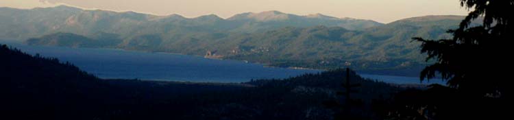
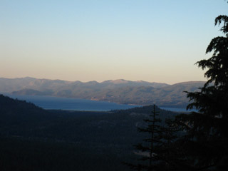
| Tahoe Sunset from above Echo Lake |
Lake Tahoe Basin Management UnitOffice Locations/Contact information |
|
South Lake Tahoe RangersThe Web SiteLake Tahoe Basin Administrative Unit The Physical Main OfficeU.S. Forest Service Lake Tahoe Basin Management Unit Forest Supervisor's Office 35 College Drive South Lake Tahoe, CA 96150 Phone: (530) 543-2600 TTY: (530) 543-0956 Seasonal OfficesThe Taylor Creek Visitor Center is three miles north of the town of South Lake Tahoe on Hwy. 89 (Also known as Emerald Bay Road). It is a right turn (toward the lake), just past the Tallac Historic Site turnoff. Phone: (530) 543-2674 Seasonal Permit stationsMeeks Bay
|
North Shore RangersLTBMU North Tahoe Forest Service Office 3080 North Lake Blvd. Tahoe City, CA 96145 (530) 583-3593 Seasonal Offices...checking... More Lake Tahoe Basin Managment Unit Contact information |
Lake Tahoe Management Unit Maps |
|
Lake Tahoe Basin Administrative Unit Lake Tahoe Basin Administrative Unit, Maps Crappy html LTBAU Map, West/South Lake. (not working) pdf LTBAU map of low resolution.
Desolation Wilderness Area Info Fee permit area. Crappy html Desolation Wilderness Map Full pdf Desolation Wilderness Map, of low resolution.
Meiss Country Roadless Area map pdf LTBAU map of the Meiss Roadless Area. Pdf map. Tahoe to Whitney Maps: Lake Tahoe to Lake Alpine |
|
top of page
View The LTBMU Main Office in a larger map |
Other Great Trips in the LTBAU: Too many to list! |
You don't have to just backpack through the LTBAU to points further South, you can enjoy short backpacking trips through the many miles of beauitiful forests, valleys mountains and meadows that surroundLake Tahoe. Tahoe Rim Trail: The ultimate Lake Tahoe backpacking trip Echo Summit to Carson Pass: from Echo Summit you can craft many short trips South Upper Truckee to Round Top Lake and Back, mid-winter. Lake Tahoe is a Winter Wonderland for backpackers Desolation Wilderness excursions: Busy in mid-Summer, but quiet in Spring, Fall, and Winter time. |
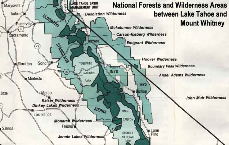 |
| Map Credit: Forest Service, Pacific Sorthwest Region, "A Guide to National Forest Wilderness in California." |
Explore Lake Tahoe!
Lake Tahoe Backpacker Resources
Our guide to the Sierra Crest, including the Tahoe to Yosemite, the Pacific Crest and the John Muir Trails